Easter Tuesday and, once again, my work rota meant I was off work whilst Lynda wasn't. I could either make the most of the day or waste it in front of the TV whilst eating Easter Eggs! I chose to make the most of the day and get out with the camera... I could eat chocolate later!
On Monday evening I plotted out a GPS route that would take me around South East Derbyshire and parts of North West Leicestershire, stopping off at a number of churches (not that I'm religious), country houses and even a ruined priory. I'd be covering around 41 miles and using the mountain bike, so that I wouldn't be restricted to just riding on-road. The mountain bike is also a lot more comfortable when riding with a loaded rucksack on your back too!
So, Tuesday morning arrived and just as I was getting out of bed so did the snow! Within just a few minutes there was a light covering of the white stuff once again - I went back to bed for an extra hour-and-a-half! By just after 9:15AM the snow was gone, the sun was out and I was on my way. The day went like this...
Just 2.5 miles from home and I'm in Elvaston Castle Country Park. The "castle" is actually a large country house dating back (in it's present form) to the early 1800's although the Elvaston Estate can be traced back past the 11th century.
Elvaston Castle - viewed along East Avenue.
Elvaston Castle - viewed across the main lake.
The Boat House on Elvaston Park Lake.
From Elvaston I took to the back roads and headed out through Shardlow to Aston-on-Trent, passing an ever increasing herd of Alpaca on the edge of the village in the process. The Alpaca have been in the fields near Aston for a few years now but I still can't get used to seeing these strange, but cute looking, animals here in Derbyshire. Large bodied sheep with extra long legs and neck! I digress... At 7.5 miles I pause in Aston-on-Trent for one quick photo - All Saints' Parish Church.
All Saints' Church - Aston-on-Trent.
Just up the road from Aston-on-Trent is Weston-on-Trent and another stop off for a church. This time it's St. Mary the Virgin, a great little church with views over the Trent Valley and the church where Lynda and I got married. Well, I had to plan this one into the ride I guess!
St. Mary the Virgin - Weston-on-Trent.
A door into St. Mary the Virgin, Weston-on-Trent.
From Weston I left the roads for a while and took to the canal and old railway paths and headed off towards Melbourne. For a while the clouds rolled back in again and so I chose to move on, only pausing for 3 quick photos during the next 3 miles.
A bridge over the canal, near Weston-on-Trent.
Old railway bridge, at the start of the Cloud Trail,
near Weston-on-Trent.
I often ride along this road (in Kings Newton) and wonder at just how it got its name...
... a quick search of the 'tinternet and it turns out that there used to be a whale bone arch here. The original bones are long gone but, apparently, a replacement pair still exist close by. Something to look out for in the future.
Once in Melbourne I had to climb off the bike for a time and walk - a "STRICTLY NO CYCLING" sign welcomed me at the entrance to Melbourne Pool. I did as I was told and enjoyed a pleasant stroll around the lake in the sunshine to view St. Michael with St. Mary Church across the lake.
St. Michael with St. Mary Church,
Melbourne - viewed across Melbourne Pool.
Boundary wall for Melbourne Hall.
Back on the bike and it's time to cross the border into Leicestershire, I'm now heading for The Priory Church of Breedon on the Hill. And, when riding a heavy mountain bike with off-road tyres, it is certainly on top of a hill. The road up to the top climbs over 110 feet in under half-a-mile with the gradient reaching around 20% in places. I was more than ready for a drink once I reached the car park!
The climb proved worthwhile though when I was greeted by the familiar sound of a Raven calling and moments later the bird came into view, closely followed by a Common Buzzard AND a Peregrine! For a short time all three birds engaged in an aerial battle over who had territorial rights to the Breedon airspace. In the end, I think a truce was called and the birds went their separate ways.
The Priory Church, Breedon on the Hill.
Back down in the village of Breedon on the Hill I paused once again to retrieve my camera from my rucksack. Firstly it was for the war memorial on the village green. The memorial, built in 1926, lists the names of the men that lost their lives in the 1st and then 2nd World Wars.
War Memorial, Breedon on the Hill.
Just a short distance further on and I came across a small building that I must have ridden past on a number of occasions in the past but never spotted before, the old village Lock Up, or Roundhouse. Built in the late 1700's it was used to detain "human offenders against the law" until they could be dealt with at the local prison!
Lock Up or Roundhouse - Breedon on the Hill.
Moving further into Leicestershire I come to Cloud Hill Quarry near the village of Worthington. Materials for road making and also lime for agricultural use are produced at this huge blot on the landscape that I found strangely attractive in the bright Spring sunshine. To get an idea of the size of the quarry click on the photo to open it in a larger size and the small white dot in the centre is a large truck!
Cloud Hill Quarry, Worthington.
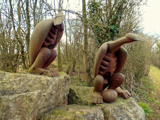
Close to the quarry I also spotted these two rather evil looking bird sculptures - made from old rock drills. It may have been the Easter holiday but I wasn't about to risk taking that egg!
Bird sculptures - Cloud Hill Quarry.
My next planned stop would be the furthest from home and the one that would take up the most of my time. I'd covered 21 miles and arrived at Grace Dieu Priory. This was the place that had set the idea of doing the photo ride in my mind. I had passed close to the site last year on a previous ride, caught a glimpse of the ruins and then looked the place up on the web when I returned home. I could easily do a "cut an' paste" job from the web giving a history of the site but it is far better to read it all on the official page, HERE!
Grace Dieu Priory, Leicestershire.
The time now was just after 1:00PM and I still had two or three places in mind that I could fit in on the way back home. The first was Staunton Harold Hall which, conveniently, sits alongside Staunton Harold Church. They also sit on a grassy bank that leads down to a lake - all very well placed for a quick photo! Both the church and the hall have very good web sites that explain their rich history - just click on the two highlighted links above.
Views of Staunton Harold Church and Hall.
Whilst passing through the Staunton Harold Estate I had to do a quick U-turn back into a small courtyard when two sculptures caught my eye.
Staunton Harold sculptures.
Onwards and upwards again, quite literally, and I headed to Calke Park. By now my legs were starting to feel the miles a little and an ever increasing head wind wasn't helping either. On any other day the hills around here wouldn't have been much of a challenge but today, on a mountain bike and carrying a rucksack, they were starting to take their toll. With 28 miles covered I was in Calke Park and enjoying a break from the pedaling.
My two targets here were St. Giles Church and then Calke Abbey itself. Further details of both can be found on the National Trust website.
St. Giles Church, Calke Abbey.
Calke Abbey.
Another six miles of windy and at times hilly cycling from Calke and I arrived in the village of Ticknall. Now, if you know the area, that may not add up to you - "six miles from Calke to Ticknall?" Well, I went the long way! Back out of the park to Calke village, then the hard climb up through Spring Wood alongside Staunton Reservoir, along the road towards Melbourne before riding the trail by the reservoir back into Ticknall. Hey, I'm a cyclist, I don't do the easy option!
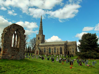
Anyway, Ticknall. My final photo stop was St. George's Church, in the heart of the village. I'd never seen the church before and only found it when it appeared on my GPS mapping software whilst planning the ride route. I'm pleased I included this one last site as it turned out to be rather photogenic. As well as the current church there are also a couple of ruined walls still standing from an earlier building.
St. George's Church, Ticknall.
All that was now left was to pack the camera into my bag one last time and head for home, just 7 miles of country lanes and cycle paths. The weather had turned out to be much better that it had threatened to be, the mountain bike had proved to be a great choice of transport and I had all the photos I'd hoped for. All in all, a great day out!
But.... half way home the bike just had to have the final say! As we reached the Crewe & Harpur pub, by the historic Swarkestone Bridge, it suddenly swerved to the left, down a set of steps into the beer garden and refused to go any further until I'd treated myself to a gorgeous pint of Sneck Lifter and a Chicken & Bacon Club Sandwich! Happy days!
Lunch is served!


No comments:
Post a Comment